
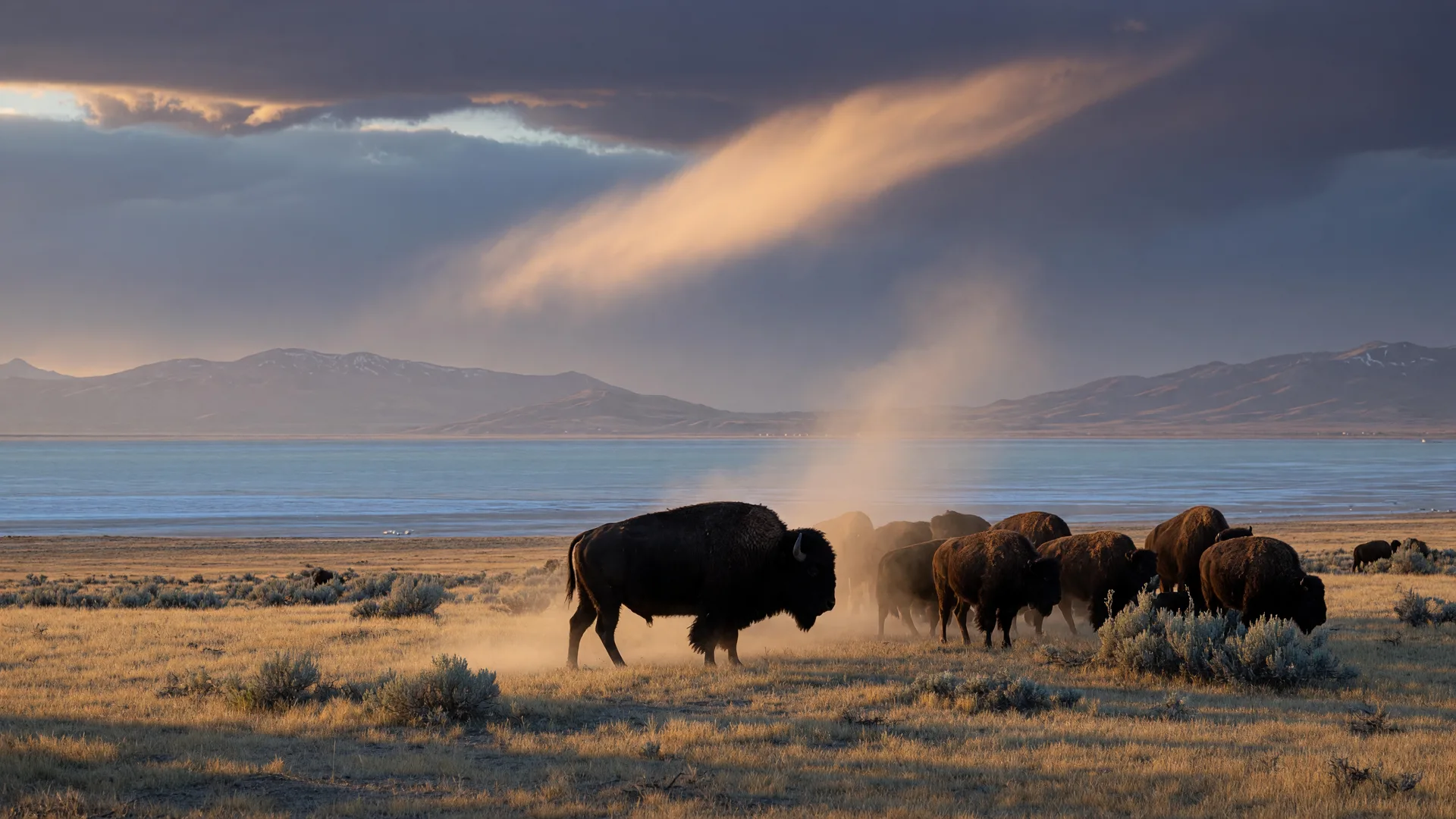
Antelope Island State Park is the largest island in the Great Salt Lake and one of Utah's most unusual day trips, reachable by car across a seven-mile causeway from the mainland. It is home to the oldest publicly owned bison herd in the nation, a herd that descends from 12 bison introduced in 1893 and still roams the island's grasslands between lake and mountain. This guide covers the park's history, the bison and the fall roundup, wildlife, trails like Frary Peak and Buffalo Point, camping and swimming, entry fees, hours, and practical tips so you can plan a visit on your own schedule.
Antelope Island at a Glance
- Location: Great Salt Lake, Davis County, roughly 41 miles north of Salt Lake City
- Access: I-15 exit 332, then about 7 miles across the Davis County Causeway (the only road in)
- Day-use entry: $15 per vehicle (up to 8 people); $10 for seniors 65+; $5 per motorcycle; $3 per cyclist or walker; Antelope Island Annual Pass $65
- Hours: Daily 6:00 a.m. to 10:00 p.m.; no admittance after the gates close; facilities closed Thanksgiving and Christmas
- The headline act: Roughly 500 to 700 bison, including the oldest publicly owned bison herd in the nation
- Best times: Spring and fall, early morning and late afternoon, when wildlife is active and the light is warm
History of the Park and the Bison Herd
The island has been part of the Great Salt Lake for thousands of years, and its modern name comes from an 1845 exploring party that saw pronghorn on the shore and called them antelope, a name that stuck even though they were not true antelope. For decades the island was private ranchland. Utah State Parks traces the modern park story and, with it, the most famous herd in the West to a single decision in 1893.
That year, with fewer than 1,000 bison left in all of North America after decades of overhunting, island owner John Dooly Sr. purchased 12 bison, 4 bulls, 4 cows, and 4 calves, and shipped them by boat across the lake to the island. Those 12 animals are the foundation of today's herd. Utah State Parks describes the herd as one of the nation's largest and oldest public bison herds, and it is widely cited as the oldest publicly owned bison herd in the nation.
The herd's management has been continuous since 1893, and it has been publicly owned since 1981, when the State of Utah purchased the southern portion of the island, roughly 26,000 acres. The herd is now managed at about 500 to 550 animals, a size that keeps the population healthy and the island's limited grassland from being overgrazed.
The Annual Bison Roundup
Every fall, Utah State Parks conducts the annual bison roundup, a tradition that has run since 1987. The roundup is the park's primary tool for keeping one of the nation's largest and oldest public bison herds healthy. It usually takes place in late October, and the exact dates are typically late fall, so check the park calendar before you plan around it.
The event happens in phases. First, riders on horseback push the free-roaming herd from the island's south end into holding corrals at the north end. Over the following days, in a phase called the working of the bison, the animals are sorted one at a time for vaccinations and individual health screenings, including checks for pregnancy and parasites. Surplus animals are then sold at a public auction, which keeps the herd at a manageable size and supports park and wildlife programs.
The roundup draws photographers and spectators from across the state, but it is a working event more than a show. Access to viewing areas can change from year to year, so confirm details, dates, and viewing policies with the park.
Wildlife Beyond Bison
Bison get the attention, but the island supports a surprising amount of wildlife for a 42-square-mile parcel of sagebrush and grassland in the middle of a salt lake. Pronghorn, the animals the island is named for, are common. Bighorn sheep and mule deer also live on the island, along with coyotes, bobcats, badgers, porcupines, and foxes.
The island is also one of the best birding spots in the state. Roughly 260 species of birds have been recorded there, including shorebirds like avocets and white-faced ibis and huge numbers of migrating waterfowl that stop over on the lake. Early morning is the best time for wildlife viewing, and binoculars are worth packing.
Bison are wild animals. Give them plenty of room, especially bulls and cows with calves. They can move surprisingly fast, and park staff routinely warn visitors not to approach them for photos. View from your vehicle or from a respectful distance.
Things to Do
Hiking: Frary Peak, Buffalo Point, and the Lakeside Trail
The signature hike is Frary Peak, which climbs to the island's highest point at 6,596 feet. The trail is roughly 6.6 to 7.1 miles round trip with about 2,100 to 2,450 feet of elevation gain, graded strenuous, and the payoff is a 360-degree view of the Great Salt Lake, the Wasatch Mountains, and the Oquirrhs. It is hiking only, dogs are not allowed, and summiting takes most hikers five hours or more with the climb factored in. Start early; the trail is fully exposed.
For a much shorter outing, Buffalo Point is about a mile round trip with roughly 240 feet of gain, rated easy to moderate, and it is one of the most popular sunset spots on the island. Panoramic lake views come quickly here, which makes it a great pick for families or anyone short on time.
The Lakeside Trail follows the shoreline from Bridger Bay around the northwestern tip of the island toward White Rock Bay, roughly 2.9 miles each way on easy, mostly level ground. It is open to hikers and cyclists, dogs are allowed on leash, and the lake views at sunset are outstanding.
Biking
The island holds more than 36 miles of trails, and many are open to mountain bikers. Popular routes include the White Rock Bay loop, the Split Rock Bay doubletrack with some strenuous climbing, and the East Shore singletrack. A bike on the causeway is a slower, quieter way to arrive, and cyclists pay the reduced $3 per person entry rate.
Camping at Bridger Bay
Bridger Bay Campground sits beside the Great Salt Lake near Bridger Bay Beach with about 26 single-family sites. It is a basic campground: vault toilets on site, no RV hookups, while potable water, flush toilets, showers, and a dump station are available about a mile away at the Bridger Bay Beach facilities. Bison roam through the campground, which is part of the charm and a reminder to keep food stored properly. Biting gnats can be a real nuisance from April through October, so bug repellent is essential.
Swimming at the Marina Beach
Yes, you can swim in the Great Salt Lake, and Antelope Island is the place to do it. The park's official swimming area is Bridger Bay Beach, just north of the marina, with restrooms and showers nearby. The water is about three to five times saltier than the ocean, so you float easily, almost without trying.
That salinity comes with caveats: rinse off thoroughly in the showers afterward, wear water shoes because the lakebed can be rocky or muddy, watch for brine flies, and be aware that the shoreline can recede a long way from the parking lots when the lake is low. Enter at your own risk and check current water conditions with the park before going in.
Great Salt Lake Water Level Notes
The Great Salt Lake has spent recent years near historically low levels, and that shapes an Antelope Island visit more than almost anything else. The lake's south arm measured roughly 4,190 feet in early fall 2026, only a couple of feet above the all-time record low of about 4,188.5 feet set in November 2022, and well below the roughly 4,198-foot healthy target.
The practical consequences: the island remains reachable by car via the causeway, but low water has closed the park's main boat ramp, so motorized launching is not available, and walking from the parking areas to the actual shoreline can be a third of a mile or more over exposed, sometimes muddy lakebed. Check the park's current conditions page before you go, and set expectations that the lake may look very different from the postcards.
Practical Visitor Information
Entry fees
Day-use entry is $15 per vehicle for up to 8 people, $10 per vehicle for seniors 65 and older, $5 per motorcycle, and $3 per person for cyclists and pedestrians. Educational groups with a prior reservation pay $2 per person plus $5 per vehicle, and commercial groups pay $5 per person plus $10 per bus. An Antelope Island Annual Pass costs $65. One detail worth knowing: the general Utah State Parks Annual Day-Use Pass does not cover the Davis County Causeway fee, so confirm which pass covers your specific visit.
Hours
The park is open daily from 6:00 a.m. to 10:00 p.m., with no admittance after the gates close. Park facilities, including the visitor center and the historic Fielding Garr Ranch, close earlier, and facilities are closed on Thanksgiving and Christmas. Check the park's facilities page for current seasonal hours.
The causeway and getting there
The island has one road access: the Davis County Causeway. From Salt Lake City, take I-15 north to exit 332, head west on Antelope Drive (SR-108) to the entrance gate, then continue about 7 miles across the causeway to the island. The causeway is the only route; the old South Causeway is not an access point. The drive from the Wasatch Front community of your choice is an easy hour or less from most of Salt Lake County.
Best times of day
Plan your visit for early morning or late afternoon. Wildlife, including the bison, is most active at dawn and dusk, the heat is far more manageable, and the light across the lake turns gold as the sun gets low. Midday in summer is hot, exposed, and bright, and the bugs are at their worst. Buffalo Point at sunset is the classic way to end a day on the island. Fall is arguably the best season overall: cooler temperatures, migrating birds, and the roundup if you time it right.
Conditions and fees change; verify with the park. Entry fees, hours, causeway status, fire restrictions, the boat ramp, and the bison roundup dates are all subject to change. Confirm the latest details on the official Utah State Parks Antelope Island page and its current conditions page before you head out.
Frequently Asked Questions
Where is Antelope Island State Park and how do I get there?
Antelope Island sits in the Great Salt Lake, roughly 41 miles north of Salt Lake City in Davis County. The only road access is the Davis County Causeway: take I-15 to exit 332, drive west on Antelope Drive to the entrance gate, then about 7 miles across the causeway to the island.
How much does it cost to enter Antelope Island?
Day-use entry is $15 per vehicle for up to 8 people, $10 per vehicle for seniors 65 and older, $5 per motorcycle, and $3 per person for cyclists and pedestrians. The Antelope Island Annual Pass is $65. The general Utah State Parks Annual Day-Use Pass does not cover the Davis County Causeway fee, so check which pass applies to your visit. Fees can change, so verify with the park.
Is the bison herd really the oldest publicly owned bison herd in the nation?
Yes. Twelve bison were introduced to the island in 1893, and the herd has been managed continuously since then. It is widely cited as the oldest publicly owned bison herd in the nation, and it came under public ownership in 1981 when Utah purchased the southern portion of the island. The herd is managed at roughly 500 to 550 animals.
When is the annual bison roundup?
The roundup is held every fall and usually takes place in late October. It has run since 1987, with riders on horseback pushing the herd into corrals for health checks, vaccinations, and a surplus auction. The exact dates are typically late fall and vary each year, so check the park calendar for the current schedule.
Can you swim in the Great Salt Lake at Antelope Island?
Yes. The park's official swimming area is Bridger Bay Beach, just north of the marina, with restrooms and nearby showers. The water is about three to five times saltier than the ocean, so you float easily. Rinse off afterward, wear water shoes, and check current water and lake-level conditions before going in.
What is the best hike on Antelope Island?
Frary Peak is the classic summit hike: 6.6 to 7.1 miles round trip, about 2,100 to 2,450 feet of gain, strenuous, with 360-degree views from the island's 6,596-foot high point. Buffalo Point is a much easier mile-round-trip sunset viewpoint, and the Lakeside Trail offers easy shoreline walking and biking from Bridger Bay toward White Rock Bay.
Thinking about living somewhere with all this within reach?
Antelope Island is an easy drive from Daybreak, South Jordan, Sandy, Draper, and every other Wasatch Front community the Stark Group serves. Adam and Natalie Stark can help you find a home base with the lake, the mountains, and the bison only minutes away. Book a free call to talk about buying, selling, or just what the market looks like in your area.
Book a CallSources & Further Reading
- Utah State Parks: Antelope Island State Park (official page)
- Utah State Parks: Antelope Island Park Fees
- Utah State Parks: Antelope Island Current Conditions
- Utah State Parks: Antelope Island Directions and Causeway Access
- Utah State Parks: Antelope Island History
- Utah State Parks: Antelope Island Bison Roundup
- Utah State Parks: Antelope Island FAQs (swimming and more)
- Utah State Parks: Antelope Island Facilities and Hours
- Visit Utah: Antelope Island State Park, Utah's Great Salt Lake Treasure
- Visit Utah: Frary Peak Trail
- AllTrails: Antelope Island State Park trails
Trail distances and elevation gains are commonly cited published figures and can vary by source. Lake levels, fees, hours, and roundup dates change frequently; always verify with Utah State Parks before your visit.
Keep Exploring
Outdoor Recreation Guides
Hiking, skiing, golf, and parks across Utah
Best Hikes on the Wasatch Front
Distances, difficulty, and trailhead fees for 11 trails
Why Utah Is a Geological Wonder
Five national parks, salt flats, and ancient lakes
Utah Lake Life
Boating, fishing, and water sports across Utah's lakes